10.5. Landsat Data
Landsat 8 data is collected over 11 bands as illustrated below.
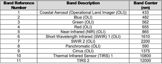
Landsat 8 band combinations are usually bands 4, 3 and 2 in the R, G and B channels for an aerial photo type image, whereas the combination of bands 6, 4 and 2 typically enhances the geology. Band 8 is used to pan-sharpen the 30 m images to 15 m resolution. The SCP plug-in will automatically pan-sharpen the RGB images if this option is selected.
Index Number |
Index Name |
Formula |
|---|---|---|
1 |
Ferric Iron “redness” |
4/2 |
2 |
Ferric Iron 2 |
(4/2)*((4+6)/5) |
3 |
Ferrous iron, coarse grained ferric iron |
(3+6)/(4+5) |
4 |
Clay, sulphate, mica, marble |
(6/7)/(5/4) |
5 |
Iron sulphate |
(2/1)-(5/4) |